
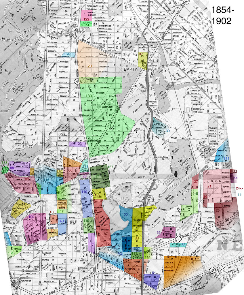
After last week’s discussion and nearly unanimous opposition to the name Tivoli North for parts of 14th Street north of Monroe in Columbia Heights, a reader did some interesting research and found the cool map above.
The reader writes:
“I don’t advocate one way or another for what names people apply to the neighborhoods (though NoMa, Atlas District, and Hill East make me slightly queasy) but I thought it was interesting to see the historical names and dates of the subdivisions. The map is based on data in a study in the journal of the Historical Society of Washington in 2002.
Obviously there are some gaps, such as the neighborhood Red Derby is in. I assume that the areas not highlighted were subdivided after 1902, the end of the study’s time period.
There is no mention of several names we use today — Park View, 16th St. Heights, Crestwood, etc. Someone had questioned if Lanier Heights was real, and it is/was (see #97).
Petworth was one of the first subdivisions laid out in accordance with the street grid of the original city, in anticipation of regulations that would soon require such patterns. At that time it did not extend towards the corner of NH and Missouri Aves.
Brookland was laid out in several stages and surrounded other subdivisions such as Metropolis View (110) and Cuckold’s Delight (11).
The names Mt. Pleasant and Pleasant Plains were already in use before these subdivisions were laid out. They referred to quite a large area, from Rock Creek Park and Adams Mill in the west, Florida Ave. in the south, Spring Rd. and Rock Creek Church Road in the north, and Park Place and North Capitol Street in the east. I don’t know if there was a clearly defined border between them, but Mt. Pleasant seems to be to the west and south and Pleasant Plains to the north and east. So to say that Pleasant Plains is a part of Columbia Heights is actually reversed; Columbia Heights was created out of part of Pleasant Plains.”
Key to the map:
11. Cuckold’s Delight, 1/21/1890 (Jackson, Irving, Hamlin, Brentwood, 15th, 16th NE)
14. Beale’s Subdivision, 10/30/1901
17. Bellevue, 5/16/1888; part of Pleasant Plains
18. Bloomingdale, 6/17/1889
20. Brightwood Park, 8/27/1890 Continues after the jump.
21. Brookland, 9/5/1887
22. Addition to Brookland, 10/15/1895
23. Addition to Brookland, 9/5/1889
24. Sherwood’s Addition to Brookland, 4/27/1901
25. South Brookland, 5/16/1889
26. West Brookland, 8/24/1894
27. West Brookland Park, 7/6/1892
36. Mt. Pleasant (Chapin Brown’s), 9/20/1883
37. Chillum Castle Manor, 5/20/1891
39. Clermont, 3/2/1895; part of Pleasant Hills & Turkey Thicket
47. Columbia Heights 11/1/1881; “Part of Mt. Pleasant and Pleasant Plains, being north part of Stone Farm; hereafter to be known as Columbia Heights.”
48. Columbia Heights 3/27/1883; “Part of Mt. Pleasant and Pleasant Plains, being south part of Stone Farm; hereafter to be known as Columbia Heights.”
49. Columbian College Lands North, 3/11/1882
50. Columbian College Lands South, 12/1867
57. Denison & Leighton’s Subdivision, 4/1844, 6/30/1884; part of Mt. Pleasant and Pleasant Plains into Lots 44-117
58. C.W. Dobbins’s Addition, 7/7/1887; part of Prospect and Mt. Pleasant
62. Eckington, 5/28/1887
63. Center Eckington, 12/15/1891
64. West Eckington, 4/6/1891
66. Edgewood, 7/19/1890
73. S.J. Goss’s Subdivision of Part of Pleasant Plains, 7/20/1874
85. Holmead Manor, 10/8/1891; part of Pleasant Plains, Lamar’s Outlet, and Slippery Hill
86. Holmead’s Subdivision of Part of Pleasant Plains, 7/3/1883
87. Howard University, 4/10/1867; part of Mt. Pleasant
88. Ingleside, 8/20/1891; part of Mt. Pleasant and Pleasant Plains
89. Walbridge’s Subdivision of Ingleside, 8/30/1893
97. Lanier Heights, 11/21/1883; parts of Jackson Hill and Mt. Pleasant
99. Le Droit Park, 6/1/1873
100. Addition to Le Droit Park, 11/14/1891; parts of Mt. Pleasant and Port Royal
101. Addition to Le Droit Park, 10/20/1892
109. Hall & Evans’ Subdivision of Meridian Hill, 9/1867
110. Metropolis View, 4/1891
113. Moore & Barber’s Addition 3/18/1901; part of Bloomingdale
114. Moore & Barber’s Second Addition 12/17/1901; part of Bloomingdale
116. Mt. Pleasant, 10/1866; part of Pleasant Plains and Lamar’s Outlet
117. Part of Mt. Pleasant, 1868
118. Breed’s Place, 7/17/1888 (within #116)
119. Wright & Dole’s Division of the Widow’s Dower, 1/7/1867; part of Mt. Pleasant
122. North Brightwood, 7/2/1901
123. North Columbia Heights, 12/4/1901
130. Petworth, 1/16/1889
133. Estate of Jno. A. Purner, 12/1881; part of Pleasant Plains
138. Rosemount Park, 4/12/1884
139. Scheutzen Park, 4/29/1892; part of Pleasant Plains
149. Todd & Brown’s Subdivision of Part of Pleasant Plains and Mt. Pleasant, 1868
155. University Heights, 4/30/1890
156. University Park, 4/23/1884; part of Mt. Pleasant
160. Washington Heights, 12/5/1882
161. Washington Heights, 2/1/1888; part of Mt. Pleasant
164. White Croft, 8/12/1901
167. Whitney Close, 12/9/1886
Recent Stories

photo by Diane Krauthamer You can talk about whatever is on your mind – quality of life issues, a beautiful tree you spotted, scuttlebutt, or any random questions/thoughts you may…
From an email: “Petworth PorchFest is coming back for a fourth year on Saturday, April 27th. We’ll have live music on porches across the Petworth neighborhood from 2-6pm and on the…
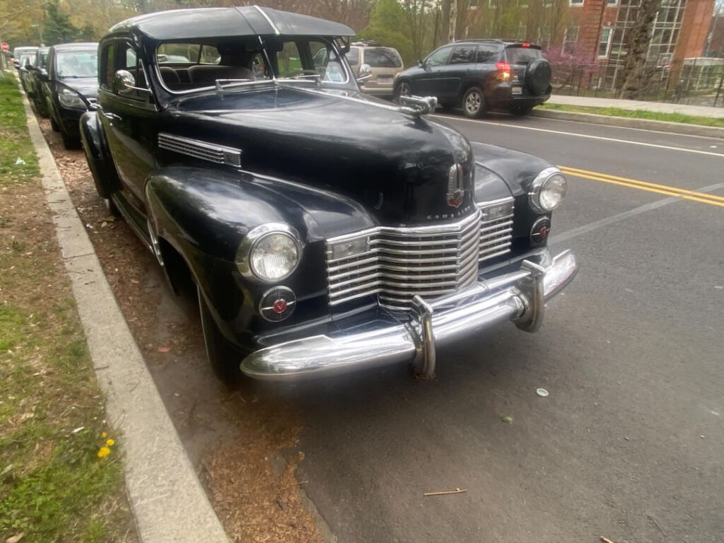
Thanks to CK for sending this super sweet “1941 Cadillac Series 61 Sedanette.”

Photo by LaTur Ed. Note: If this was you, please email [email protected] so I can put you in touch with OP. “Dear PoPville, Looking for a Quincy that was at…

For many remote workers, a messy home is distracting.
You’re getting pulled into meetings, and your unread emails keep ticking up. But you can’t focus because pet hair tumbleweeds keep floating across the floor, your desk has a fine layer of dust and you keep your video off in meetings so no one sees the chaos behind you.
It’s no secret a dirty home is distracting and even adds stress to your life. And who has the energy to clean after work? That’s why it’s smart to enlist the help of professionals, like Well-Paid Maids.

Unlock Peace of Mind for Your Family! Join our FREE Estate Planning Webinar for Parents.
🗓️ Date: April 25, 2024
🕗 Time: 8:00 p.m.
PowerPoint Party in Adams Morgan

Make a funny PowerPoint, all the cool kids in DC are doing it!
Make a 5 minute or less PowerPoint presentation on whatever you want!• Defend your unpopular opinions!
NoMa Farmers Market at Third Street

The NoMa Farmers Market is returning for its third season in an exciting new location! This season, we’re expanding and relocating from Alethia Tanner Park to Third Street between N and M Streets NE at the nexus of NoMa and